Geolocate

Kilgore topographic map

Click on the map to display elevation.

About this map

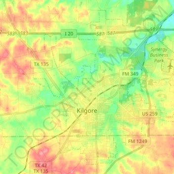
Name: Kilgore topographic map, elevation, terrain.

Location: Kilgore, Gregg County, Texas, United States (32.35330 -94.91663 32.44676 -94.79177)

Average elevation: 354 ft

Minimum elevation: 233 ft

Maximum elevation: 482 ft

Gregg County trails, hiking, mountain biking, running and outdoor activities

Other topographic maps

Click on a map to view its topography, its elevation and its terrain.

Liberty City

United States > Texas > Gregg County

Average elevation: 381 ft

Gladewater Park

United States > Texas > Gregg County

Average elevation: 322 ft

Gear up for your next adventure:

🔭Stargazing Telescopes - Perfect for camping in low-light pollution areas shown on maps
🪶Multi‑Purpose Knife - Useful blade for camp and trail
🦟Ultrasonic Repellers - Create a bug-free zone at your camp or rest stop
🔥Fast-Boil Camping Stoves - Efficient cooking systems for quick trail meals
🛶Inflatable Kayak - Portable kayak for rivers, lakes, and expeditions

As an Amazon Associate, this site earns from qualifying purchases at no extra cost to you.