Geolocate

Liberty City topographic map

Click on the map to display elevation.

About this map

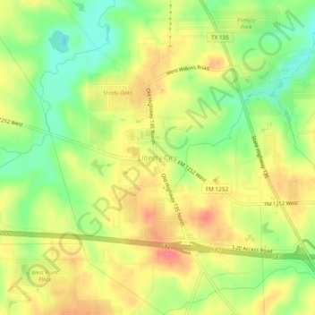
Name: Liberty City topographic map, elevation, terrain.

Location: Liberty City, Gregg County, Texas, United States (32.42543 -94.96855 32.46543 -94.92855)

Average elevation: 381 ft

Minimum elevation: 269 ft

Maximum elevation: 476 ft

Gregg County trails, hiking, mountain biking, running and outdoor activities

Other topographic maps

Click on a map to view its topography, its elevation and its terrain.

Longview

United States > Texas > Gregg County

Average elevation: 344 ft

Gladewater

United States > Texas > Gregg County

Average elevation: 335 ft

Kilgore

United States > Texas > Gregg County

Average elevation: 354 ft

White Oak

United States > Texas > Gregg County

Average elevation: 361 ft

Longview

United States > Texas > Gregg County

Average elevation: 344 ft

Longview

United States > Texas > Gregg County

Average elevation: 344 ft

Easton

United States > Texas > Gregg County

Average elevation: 279 ft

Gear up for your next adventure:

Backpacking Tents - Weight-optimized shelters for multi-day topographic surveys
🧥Waterproof Jacket for Hiking - Breathable and rugged rain jacket for outdoor excursions
🌧️Backpack Rain Cover - Keep gear dry in wet weather
🔌USB Car Charger - Car charger for on‑the‑go power needs
🪶Survival Guide Book - Expert advice for emergency preparedness

As an Amazon Associate, this site earns from qualifying purchases at no extra cost to you.