
Vail topographic map
Click on the map to display elevation.
Vail
Vail's average elevation is 8,150 feet (2,480 m) above sea level. The town has a total area of 4.5 square miles (12 km2), with no lakes (there is, however, at least one pond). Gore Creek flows from east to west through the center of town.
About this map
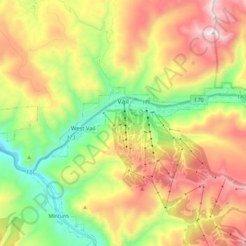
Name: Vail topographic map, elevation, terrain.
Location: Vail, Eagle County, Colorado, 81657, United States (39.61496 -106.43944 39.65077 -106.27975)
Average elevation: 9,629 ft
Minimum elevation: 7,635 ft
Maximum elevation: 12,113 ft
Eagle County trails, hiking, mountain biking, running and outdoor activities
Other topographic maps
Click on a map to view its topography, its elevation and its terrain.
Bond
United States > Colorado > Eagle County
Bond is located at coordinates 39°52′28″N 106°41′14″W / 39.8744°N 106.6873°W / 39.8744; -106.6873, 133 miles (214 kilometers) west of Denver at an elevation of 6,739 feet (2,054 m). It is located along the Colorado River, and is at the southern terminus of the Colorado River Headwaters National Scenic Byway.
Average elevation: 7,303 ft
Vail
United States > Colorado > Eagle County
Vail's average elevation is 8,150 feet (2484 m) above sea level. The town has a total area of 4.5 square miles (12 km2), with no lakes (there is, however, at least one pond). Gore Creek flows from east to west through the center of town.
Average elevation: 9,688 ft