
Make a donation
Gear up for your next adventure:
As an Amazon Associate, this site earns from qualifying purchases at no extra cost to you.
Aldbury topographic map
Click on the map to display elevation.
Make a donation
Gear up for your next adventure:
As an Amazon Associate, this site earns from qualifying purchases at no extra cost to you.
About this map
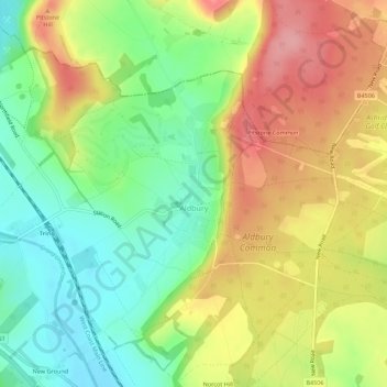
Name: Aldbury topographic map, elevation, terrain.
Location: Aldbury, Dacorum, Hertfordshire, England, United Kingdom (51.78694 -0.63597 51.81994 -0.58094)
Average elevation: 571 ft
Minimum elevation: 390 ft
Maximum elevation: 781 ft
Make a donation
Gear up for your next adventure:
As an Amazon Associate, this site earns from qualifying purchases at no extra cost to you.
Other topographic maps
Click on a map to view its topography, its elevation and its terrain.
Make a donation
Gear up for your next adventure:
As an Amazon Associate, this site earns from qualifying purchases at no extra cost to you.
Saint Margarets Copse
United Kingdom > England > Hertfordshire > Dacorum > Great Gaddesden
Average elevation: 472 ft
Hammerfield
United Kingdom > England > Hertfordshire > Dacorum > Hemel Hempstead
Average elevation: 400 ft
Make a donation
Gear up for your next adventure:
As an Amazon Associate, this site earns from qualifying purchases at no extra cost to you.
Tringford Reservoir
United Kingdom > England > Hertfordshire > Dacorum > Tring > Wilstone
Average elevation: 390 ft
Little Heath
United Kingdom > England > Hertfordshire > Dacorum > Potten End
Average elevation: 453 ft
Make a donation
Gear up for your next adventure:
As an Amazon Associate, this site earns from qualifying purchases at no extra cost to you.
Dixon's Gap Bridge
United Kingdom > England > Hertfordshire > Dacorum > Wilstone > Gubblecote
Average elevation: 331 ft
Make a donation
Gear up for your next adventure:
As an Amazon Associate, this site earns from qualifying purchases at no extra cost to you.
Westbrook Mere
United Kingdom > England > Hertfordshire > Dacorum > Bourne End
Average elevation: 410 ft
Trowley Bottom
United Kingdom > England > Hertfordshire > Dacorum > Flamstead
Average elevation: 456 ft
Nettleden
United Kingdom > England > Hertfordshire > Dacorum > Great Gaddesden
Average elevation: 489 ft
Make a donation
Gear up for your next adventure:
As an Amazon Associate, this site earns from qualifying purchases at no extra cost to you.
Bovingdon Green
United Kingdom > England > Hertfordshire > Dacorum > Bovingdon
Average elevation: 495 ft
Long Marston
United Kingdom > England > Hertfordshire > Dacorum > Long Marston
Average elevation: 302 ft
Frithsden Beeches
United Kingdom > England > Hertfordshire > Dacorum > Potten End
Average elevation: 525 ft
Make a donation
Gear up for your next adventure:
As an Amazon Associate, this site earns from qualifying purchases at no extra cost to you.
Make a donation
Gear up for your next adventure:
As an Amazon Associate, this site earns from qualifying purchases at no extra cost to you.