

Corner Hall topographic map
Click on the map to display elevation.
About this map
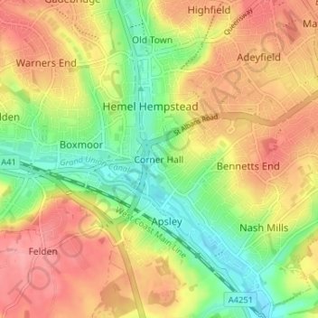
Name: Corner Hall topographic map, elevation, terrain.
Average elevation: 394 ft
Minimum elevation: 246 ft
Maximum elevation: 525 ft
Other topographic maps
Click on a map to view its topography, its elevation and its terrain.
Tringford Reservoir
United Kingdom > England > Hertfordshire > Dacorum > Tring > Wilstone
Average elevation: 390 ft
Phasels Wood
United Kingdom > England > Hertfordshire > Dacorum > Kings Langley > Felden
Average elevation: 420 ft

Little Gaddesden
United Kingdom > England > Hertfordshire > Dacorum > Little Gaddesden
Average elevation: 574 ft

Berkhamsted
United Kingdom > England > Hertfordshire > Dacorum > Northchurch
The layout of Berkhamsted's centre is typical of a medieval market settlement: the linear High Street (aligned on the Akeman Street) forms the spine of the town (roughly aligned east–west), from which extend medieval burgage plots (to the north and south). The surviving burgage plot layout is the result of a…
Average elevation: 466 ft
Saint Margarets Copse
United Kingdom > England > Hertfordshire > Dacorum > Great Gaddesden
Average elevation: 472 ft
Northchurch
United Kingdom > England > Hertfordshire > Dacorum > Northchurch
Average elevation: 531 ft


Great Gaddesden
United Kingdom > England > Hertfordshire > Dacorum > Gaddesden Row
Average elevation: 479 ft
Westbrook Mere
United Kingdom > England > Hertfordshire > Dacorum > Bourne End
Average elevation: 410 ft

Gadebridge Park
United Kingdom > England > Hertfordshire > Dacorum > Piccotts End
Average elevation: 404 ft
Frithsden Beeches
United Kingdom > England > Hertfordshire > Dacorum > Potten End
Average elevation: 525 ft
Berkhamsted
United Kingdom > England > Hertfordshire > Dacorum
The layout of Berkhamsted's centre is typical of a medieval market settlement: the linear High Street (aligned on the Akeman Street) forms the spine of the town (roughly aligned east–west), from which extend medieval burgage plots (to the north and south). The surviving burgage plot layout is the result of a…
Average elevation: 476 ft
Berkhamsted
United Kingdom > England > Hertfordshire > Dacorum
The layout of Berkhamsted's centre is typical of a medieval market settlement: the linear High Street (aligned on the Akeman Street) forms the spine of the town (roughly aligned east–west), from which extend medieval burgage plots (to the north and south). The surviving burgage plot layout is the result of a…
Average elevation: 476 ft