Geolocate

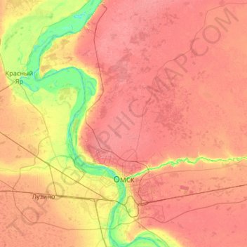
Omsk topographic map

Click on the map to display elevation.

Omsk

Omsk is in the south of the West Siberian Plain, along the banks of the north-flowing Irtysh, at its confluence with the Om River. The city has an elevation of 87 meters (285 ft) above mean sea level at its highest point.

Wikipedia (CC-BY-SA 3.0)

About this map

Name: Omsk topographic map, elevation, terrain.

Location: Omsk, Omsk Oblast, Siberian Federal District, Russia (54.82404 73.09753 55.42657 73.65994)

Average elevation: 351 ft

Minimum elevation: 207 ft

Maximum elevation: 469 ft

Other topographic maps

Click on a map to view its topography, its elevation and its terrain.

Хутора

Russia > Omsk Oblast > Tyukalinsky District

Average elevation: 341 ft

Ust-Ishim

Russia > Omsk Oblast > Ust-Ishimsky District

Average elevation: 174 ft

Poltavka

Russia > Omsk Oblast > Poltavsky District

Average elevation: 407 ft

Odesskoye

Russia > Omsk Oblast > Odessky District

Average elevation: 413 ft

Ukrainka

Russia > Omsk Oblast > Isilkulsky District

Average elevation: 407 ft

Домбай

Russia > Omsk Oblast > Maryanovsky District

Average elevation: 390 ft

Maryanovka

Russia > Omsk Oblast > Maryanovsky District

Average elevation: 364 ft

Tevriz

Russia > Omsk Oblast > Tevrizsky District

Average elevation: 190 ft

Gear up for your next adventure:

🔭Compact Binoculars - HD vision for scouting terrain and identifying distant landmarks
🔦Powerful Headlamps - Ultra-bright hands-free lighting for night navigation
🦺Reflective Outdoor Gear - Safety gear for low‑light conditions
🧯Portable Fire Pit - Compact fire pit for camping spots
🎒Hydration Pack - Hands‑free water reservoir for long hikes

As an Amazon Associate, this site earns from qualifying purchases at no extra cost to you.