
Make a donation
Gear up for your next adventure:
As an Amazon Associate, this site earns from qualifying purchases at no extra cost to you.
Wemmel topographic map
Click on the map to display elevation.
Make a donation
Gear up for your next adventure:
As an Amazon Associate, this site earns from qualifying purchases at no extra cost to you.
About this map
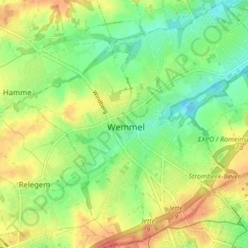
Name: Wemmel topographic map, elevation, terrain.
Location: Wemmel, Hal-Vilvorde, Brabant flamand, 1780, Belgique (50.89039 4.27780 50.92808 4.33896)
Average elevation: 177 ft
Minimum elevation: 89 ft
Maximum elevation: 282 ft
Make a donation
Gear up for your next adventure:
As an Amazon Associate, this site earns from qualifying purchases at no extra cost to you.
Other topographic maps
Click on a map to view its topography, its elevation and its terrain.
Goudveerdegem
Belgique > Brabant flamand > Hal-Vilvorde > Dilbeek > Schepdael
Average elevation: 190 ft
Make a donation
Gear up for your next adventure:
As an Amazon Associate, this site earns from qualifying purchases at no extra cost to you.
Make a donation
Gear up for your next adventure:
As an Amazon Associate, this site earns from qualifying purchases at no extra cost to you.
Château d'Ophem
Belgique > Brabant flamand > Hal-Vilvorde > Wezembeek-Oppem > Ophem
Average elevation: 246 ft
Make a donation
Gear up for your next adventure:
As an Amazon Associate, this site earns from qualifying purchases at no extra cost to you.
Sept-Fontaines
Belgique > Brabant flamand > Hal-Vilvorde > Rhode-Saint-Genèse
Average elevation: 315 ft
Make a donation
Gear up for your next adventure:
As an Amazon Associate, this site earns from qualifying purchases at no extra cost to you.
Make a donation
Gear up for your next adventure:
As an Amazon Associate, this site earns from qualifying purchases at no extra cost to you.
Wezembeek
Belgique > Brabant flamand > Hal-Vilvorde > Wesembeek-Ophem > Wesembeek
Average elevation: 207 ft
Make a donation
Gear up for your next adventure:
As an Amazon Associate, this site earns from qualifying purchases at no extra cost to you.
Make a donation
Gear up for your next adventure:
As an Amazon Associate, this site earns from qualifying purchases at no extra cost to you.
Rattendaal
Belgique > Brabant flamand > Hal-Vilvorde > Leeuw-Saint-Pierre > Rattendaal
Average elevation: 128 ft
Make a donation
Gear up for your next adventure:
As an Amazon Associate, this site earns from qualifying purchases at no extra cost to you.