Geolocate

Toledo topographic map

Click on the map to display elevation.

About this map
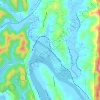
Name: Toledo topographic map, elevation, terrain.

Location: Toledo, Lincoln County, Oregon, 97391, United States (44.59906 -123.95459 44.63829 -123.91294)

Average elevation: 121 ft

Minimum elevation: -16 ft

Maximum elevation: 594 ft

Lincoln County trails, hiking, mountain biking, running and outdoor activities

Other topographic maps

Click on a map to view its topography, its elevation and its terrain.
Otter Rock

United States > Oregon > Lincoln County

Average elevation: 20 ft

Logsden

United States > Oregon > Lincoln County

Average elevation: 390 ft

Tidewater

United States > Oregon > Lincoln County

Average elevation: 728 ft

Seal Rock

United States > Oregon > Lincoln County

Average elevation: 20 ft

Bayshore

United States > Oregon > Lincoln County

Average elevation: 49 ft

Wakonda Beach

United States > Oregon > Lincoln County

Average elevation: 66 ft

Tidewater

United States > Oregon > Lincoln County

Average elevation: 728 ft

Beverly Beach

United States > Oregon > Lincoln County

Average elevation: 95 ft

Eddyville

United States > Oregon > Lincoln County

Average elevation: 430 ft

Agate Beach

United States > Oregon > Lincoln County > Newport

Average elevation: 138 ft

Logsden

United States > Oregon > Lincoln County

Average elevation: 390 ft

Gear up for your next adventure:

🛠️Outdoor Gear Repair Kit - Essential tools to fix gear on the trail
🪶Thermal Camp Blanket - Extra warmth for cold nights
🧦Merino Wool Socks - Moisture-wicking, blister-preventing socks for long treks
🪓Survival Multi‑Tool - Versatile tool for camp and trail tasks
🧣Hiking Neck Gaiter - Multi‑use neck protection for outdoor weather

As an Amazon Associate, this site earns from qualifying purchases at no extra cost to you.