Geolocate

Toledo topographic map

Click on the map to display elevation.

About this map

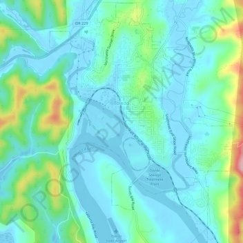
Name: Toledo topographic map, elevation, terrain.

Location: Toledo, Lincoln County, Oregon, United States (44.59906 -123.95459 44.63829 -123.91294)

Average elevation: 121 ft

Minimum elevation: -16 ft

Maximum elevation: 594 ft

Lincoln County trails, hiking, mountain biking, running and outdoor activities

Other topographic maps

Click on a map to view its topography, its elevation and its terrain.

Otter Rock

United States > Oregon > Lincoln County

Average elevation: 20 ft

Logsden

United States > Oregon > Lincoln County

Average elevation: 390 ft

Tidewater

United States > Oregon > Lincoln County

Average elevation: 728 ft

Seal Rock

United States > Oregon > Lincoln County

Average elevation: 20 ft

Bayshore

United States > Oregon > Lincoln County

Average elevation: 49 ft

Tidewater

United States > Oregon > Lincoln County

Average elevation: 728 ft

Eddyville

United States > Oregon > Lincoln County

Average elevation: 430 ft

Beverly Beach

United States > Oregon > Lincoln County

Average elevation: 95 ft

Logsden

United States > Oregon > Lincoln County

Average elevation: 390 ft

Agate Beach

United States > Oregon > Lincoln County > Newport

Average elevation: 138 ft

Gear up for your next adventure:

🧢Outdoor Hiking Hat - Sun protection hat for outdoor explorers
🪵Folding Camp Saw - Compact saw for wood and campsite work
👓Polarized Sunglasses - Outdoor sunglasses for glare reduction
🧼Biodegradable Camping Soap - Eco‑friendly soap for outdoor hygiene
🪶Trail Camera - Capture wildlife on your hikes

As an Amazon Associate, this site earns from qualifying purchases at no extra cost to you.