
Wills Point topographic map
Click on the map to display elevation.
Wills Point
Founded in 1873, Wills Point gets its name from an early American settler, William Wills, who had arrived in the area circa 1848. Wills eventually purchased a cabin from Adam Sullivan in 1852. The name 'point' may also derive from the shape of the original timberline near the cabin, though there have been unsubstantiated arguments that the name relates to the area's elevation. The layout of the city was the work of engineer General Grenville M. Dodge of the California Construction Company. The downtown streets were laid with red bricks upon packed sand in the 1920s by locals and remain in use. Downtown Wills Point has many of its original buildings that are over one hundred years old including the Wills cabin, a drug store, a dry good store, and a law office. Governor George W. Bush officially named Wills Point the Bluebird Capital of Texas in 1995.
About this map
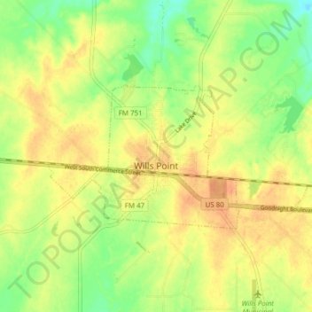
Name: Wills Point topographic map, elevation, terrain.
Location: Wills Point, Van Zandt County, Texas, United States (32.69625 -96.03489 32.72622 -95.95807)
Average elevation: 509 ft
Minimum elevation: 436 ft
Maximum elevation: 561 ft
Van Zandt County trails, hiking, mountain biking, running and outdoor activities
Other topographic maps
Click on a map to view its topography, its elevation and its terrain.