
Ben Wheeler topographic map
Click on the map to display elevation.
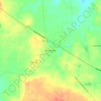
About this map
Name: Ben Wheeler topographic map, elevation, terrain.
Location: Ben Wheeler, Van Zandt County, Texas, 75744, United States (32.42641 -95.72419 32.46641 -95.68419)
Average elevation: 541 ft
Minimum elevation: 463 ft
Maximum elevation: 620 ft
Van Zandt County trails, hiking, mountain biking, running and outdoor activities
Other topographic maps
Click on a map to view its topography, its elevation and its terrain.
Wills Point
United States > Texas > Van Zandt County
Founded in 1873, Wills Point gets its name from an early American settler, William Wills, who had arrived in the area circa 1848. Wills eventually purchased a cabin from Adam Sullivan in 1852. The name 'point' may also derive from the shape of the original timberline near the cabin, though there have been…
Average elevation: 509 ft
Wills Point
United States > Texas > Van Zandt County
Founded in 1873, Wills Point derives its name from an early American settler, William Wills, who had arrived in the area circa 1848. Wills eventually purchased a cabin from Adam Sullivan in 1852. The name 'point' may also derive from the shape of the original timberline near the cabin, though there have been…
Average elevation: 509 ft