
Weber Lake topographic map
Click on the map to display elevation.
About this map
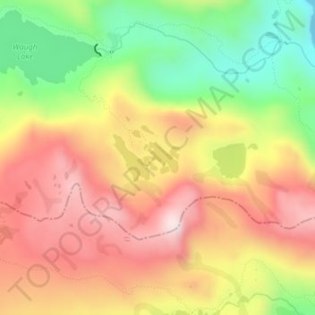
Name: Weber Lake topographic map, elevation, terrain.
Location: Weber Lake, Mono County, California, United States (37.73973 -119.17984 37.74381 -119.17254)
Average elevation: 9,862 ft
Minimum elevation: 9,012 ft
Maximum elevation: 10,594 ft
Mono County trails, hiking, mountain biking, running and outdoor activities
Other topographic maps
Click on a map to view its topography, its elevation and its terrain.
Lee Vining
United States > California > Mono County
Lee Vining (formerly Leevining, Poverty Flat, and Lakeview) is an unincorporated community and census-designated place (CDP) in Mono County, California, United States. It is located 25 miles (40 km) south-southeast of Bridgeport, at an elevation of 6,781 feet (2,067 m). Lee Vining is located on the southwest…
Average elevation: 7,152 ft
Mono Lake Tufa State Natural Reserve
United States > California > Mono County
Average elevation: 6,857 ft
June Lake
United States > California > Mono County
June Lake is an unincorporated community and census-designated place (CDP) in Mono County, California, United States. It is located against the southern rim of the Mono Basin, 12.5 miles (20 km) south of Lee Vining, at an elevation of 7,654 feet (2,333 m).
Average elevation: 8,360 ft