
June Lake topographic map
Click on the map to display elevation.
June Lake
June Lake is an unincorporated community and census-designated place (CDP) in Mono County, California, United States. It is located against the southern rim of the Mono Basin, 12.5 miles (20 km) south of Lee Vining, at an elevation of 7,654 feet (2,333 m).
About this map
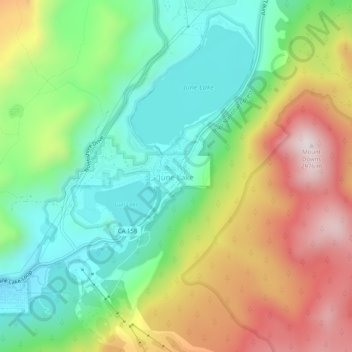
Name: June Lake topographic map, elevation, terrain.
Location: June Lake, Mono County, California, 93529, United States (37.75853 -119.09625 37.79853 -119.05625)
Average elevation: 8,360 ft
Minimum elevation: 7,451 ft
Maximum elevation: 9,754 ft
Mono County trails, hiking, mountain biking, running and outdoor activities
Other topographic maps
Click on a map to view its topography, its elevation and its terrain.
Mono Lake
United States > California > Mono County
Lake Russell was the prehistoric predecessor to Mono Lake, during the Pleistocene. Its shoreline reached the modern-day elevation of 7,480 feet (2,280 m), about 1,100 feet (330 m) higher than the present-day lake. As of 1.6 million years ago, Lake Russell discharged to the northeast, into the Walker River…
Average elevation: 6,588 ft