Geolocate

Wibrin topographic map

Click on the map to display elevation.

About this map

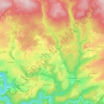
Name: Wibrin topographic map, elevation, terrain.

Location: Wibrin, Houffalize, Bastogne, Luxembourg, Wallonia, Belgium (50.13291 5.68265 50.20218 5.75562)

Average elevation: 1,391 ft

Minimum elevation: 843 ft

Maximum elevation: 1,896 ft

Other topographic maps

Click on a map to view its topography, its elevation and its terrain.

Ollomont

Belgium > Luxembourg > Bastogne > Houffalize

Average elevation: 1,234 ft

Ourthe

Belgium > Luxembourg > Bastogne

Average elevation: 1,611 ft

Gouvy

Belgium > Luxembourg > Bastogne > Gouvy

Average elevation: 1,539 ft

Regné

Belgium > Luxembourg > Bastogne

Average elevation: 1,759 ft

Rogery

Belgium > Luxembourg > Bastogne > Rogery

Average elevation: 1,591 ft

Gear up for your next adventure:

🔥Plasma Lighters - Windproof lighters that work in any weather condition
🌎3D Topographic Globes - Raised relief globes for a tactile understanding of geography
🌡️Portable Weather Meter - Track weather conditions on the trail
👓Polarized Sunglasses - Outdoor sunglasses for glare reduction
🛰️Handheld GPS Units - Professional satellite navigators for precise backcountry mapping

As an Amazon Associate, this site earns from qualifying purchases at no extra cost to you.