Geolocate

Ourthe topographic map

Click on the map to display elevation.

About this map

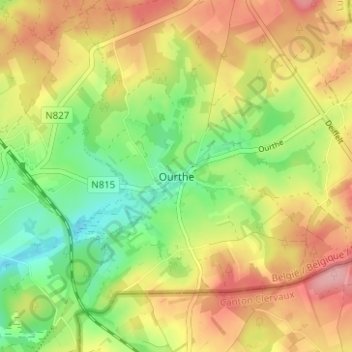
Name: Ourthe topographic map, elevation, terrain.

Location: Ourthe, Gouvy, Bastogne, Luxembourg, Wallonia, 6672, Belgium (50.16838 5.96147 50.20838 6.00147)

Average elevation: 1,611 ft

Minimum elevation: 1,407 ft

Maximum elevation: 1,824 ft

Other topographic maps

Click on a map to view its topography, its elevation and its terrain.

Wibrin

Belgium > Luxembourg > Bastogne

Average elevation: 1,391 ft

Gear up for your next adventure:

🪶Camp Gear Gift Set - Perfect gift bundle for outdoor fans
🧭Compass with Lanyard - Easy‑carry compass for navigation
🚪Portable Camp Chair - Foldable chair for comfort at camp
🗺️Topographic Maps - Detailed topo maps for hiking, exploring and outdoor navigation
📦Gear Storage Bags - Organize and protect outdoor equipment

As an Amazon Associate, this site earns from qualifying purchases at no extra cost to you.