
Town of Brule topographic map
Interactive map
Click on the map to display elevation.
About this map
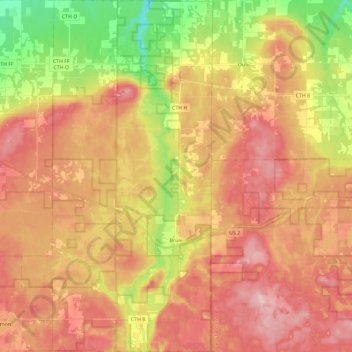
Name: Town of Brule topographic map, elevation, terrain.
Average elevation: 1,073 ft
Minimum elevation: 751 ft
Maximum elevation: 1,309 ft
Other topographic maps
Click on a map to view its topography, its elevation and its terrain.
City of Superior
United States > Wisconsin > Douglas County
City of Superior, Douglas County, Wisconsin, 54880, United States
Average elevation: 722 ft
Solon Springs
United States > Wisconsin > Douglas County
Solon Springs, Douglas County, Wisconsin, United States
Average elevation: 1,096 ft
Oliver
United States > Wisconsin > Douglas County
Oliver, Douglas County, Wisconsin, United States
Average elevation: 679 ft
Lake Nebagamon
United States > Wisconsin > Douglas County
Lake Nebagamon, Douglas County, Wisconsin, 54849, United States
Average elevation: 1,152 ft
Dairyland
United States > Wisconsin > Douglas County
Dairyland, Town of Dairyland, Douglas County, Wisconsin, United States
Average elevation: 1,112 ft
Town of Maple
United States > Wisconsin > Douglas County
Town of Maple, Douglas County, Wisconsin, 54854, United States
Average elevation: 991 ft
Bennett
United States > Wisconsin > Douglas County
Bennett, Town of Bennett, Douglas County, Wisconsin, United States
Average elevation: 1,207 ft
Big Manitou Falls
United States > Wisconsin > Douglas County > Town of Superior
Big Manitou Falls, Town of Superior, Douglas County, Wisconsin, United States
Average elevation: 968 ft
South Range
United States > Wisconsin > Douglas County
South Range, Town of Parkland, Douglas County, Wisconsin, 54874, United States
Average elevation: 778 ft
Foxboro
United States > Wisconsin > Douglas County
Foxboro, Town of Summit, Douglas County, Wisconsin, United States
Average elevation: 909 ft
Poplar
United States > Wisconsin > Douglas County
Poplar, Douglas County, Wisconsin, 54864, United States
Average elevation: 1,001 ft