
Ráquira topographic map
Interactive map
Click on the map to display elevation.
About this map
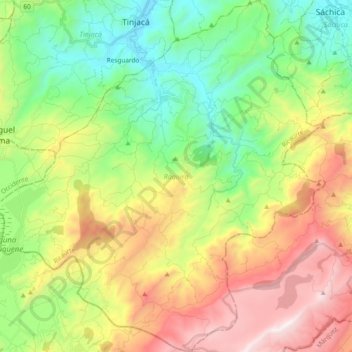
Name: Ráquira topographic map, elevation, terrain.
Location: Ráquira, Boyacá, Colombie (5.40347 -73.72398 5.59054 -73.54561)
Average elevation: 8,783 ft
Minimum elevation: 6,864 ft
Maximum elevation: 11,765 ft
Other topographic maps
Click on a map to view its topography, its elevation and its terrain.
Villa de Leyva
Villa de Leyva, Ricaurte, Boyacá, RAP (Especial) Central, Colombie
Average elevation: 7,927 ft
Miraflores
Miraflores, Lengupá, Boyacá, RAP (Especial) Central, Colombie
Average elevation: 6,375 ft
Villa de Leyva
Colombie > Boyacá > Villa de Leyva
Villa de Leyva, Boyacá, 15401, Colombie
Average elevation: 8,770 ft