
Muzo topographic map
Interactive map
Click on the map to display elevation.
About this map
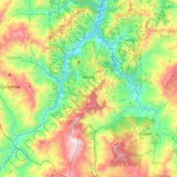
Name: Muzo topographic map, elevation, terrain.
Location: Muzo, Occidente, Boyacá, Colombie (5.43279 -74.17663 5.60880 -74.04966)
Average elevation: 3,337 ft
Minimum elevation: 1,421 ft
Maximum elevation: 6,286 ft
Other topographic maps
Click on a map to view its topography, its elevation and its terrain.
Villa de Leyva
Villa de Leyva, Ricaurte, Boyacá, RAP (Especial) Central, Colombie
Average elevation: 7,927 ft
Miraflores
Miraflores, Lengupá, Boyacá, RAP (Especial) Central, Colombie
Average elevation: 6,375 ft
Villa de Leyva
Colombie > Boyacá > Villa de Leyva
Villa de Leyva, Boyacá, 15401, Colombie
Average elevation: 8,770 ft