
Uummannaq topographic map
Interactive map
Click on the map to display elevation.
About this map
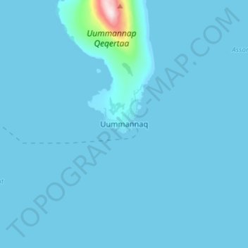
Name: Uummannaq topographic map, elevation, terrain.
Location: Uummannaq, Avannaata, 3061, Greenland (70.63489 -52.16687 70.71489 -52.08687)
Average elevation: 79 ft
Minimum elevation: -3 ft
Maximum elevation: 3,576 ft
Other topographic maps
Click on a map to view its topography, its elevation and its terrain.
Jakobshavn Glacier
Jakobshavn Glacier, Avannaata, Greenland
Average elevation: 1,483 ft
Upernivik Island
Upernivik Island, Avannaata, Greenland
Average elevation: 1,969 ft