Geolocate

Ravenna topographic map

Click on the map to display elevation.

About this map

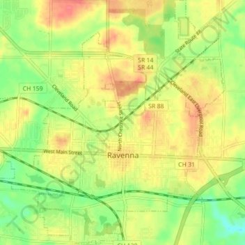
Name: Ravenna topographic map, elevation, terrain.

Location: Ravenna, Portage County, Ohio, 44266, United States (41.13838 -81.27892 41.19079 -81.21313)

Average elevation: 1,102 ft

Minimum elevation: 1,004 ft

Maximum elevation: 1,188 ft

Portage County trails, hiking, mountain biking, running and outdoor activities

Other topographic maps

Click on a map to view its topography, its elevation and its terrain.

Mantua Center

United States > Ohio > Portage County

Average elevation: 1,191 ft

Brady Lake

United States > Ohio > Portage County

Average elevation: 1,076 ft

Kent

United States > Ohio > Portage County > Kent > Kent

Average elevation: 1,079 ft

Gear up for your next adventure:

🌄Hiking Binoculars - Compact binoculars for scenic views and trail spotting
🔦LED Headlamp - Bright and durable LED headlamp for night navigation
🪓Survival Multi‑Tool - Versatile tool for camp and trail tasks
🪑Portable Camp Table - Compact table for campsite meals
🛏️Cold Weather Sleeping Bag - Warm sleeping bag for cold conditions

As an Amazon Associate, this site earns from qualifying purchases at no extra cost to you.