
Make a donation
Gear up for your next adventure:
As an Amazon Associate, this site earns from qualifying purchases at no extra cost to you.
Mimika topographic map
Click on the map to display elevation.
Make a donation
Gear up for your next adventure:
As an Amazon Associate, this site earns from qualifying purchases at no extra cost to you.
About this map
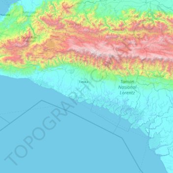
Name: Mimika topographic map, elevation, terrain.
Location: Mimika, Central Papua, Western New Guinea, 99971, Indonesia (-5.23979 134.88538 -4.02861 137.94896)
Average elevation: 2,119 ft
Minimum elevation: -16 ft
Maximum elevation: 15,499 ft
Make a donation
Gear up for your next adventure:
As an Amazon Associate, this site earns from qualifying purchases at no extra cost to you.
Other topographic maps
Click on a map to view its topography, its elevation and its terrain.
Tembagapura
Indonesia > Central Papua > Mimika
Tembagapura is situated on a rocky plain at an altitude of 1,930 metres (6,330 ft) at the base of Mount Zaagkam, which lies 16 kilometres (9.9 mi) southeast of the mine. The town is in the Sudirman Range, not far from Puncak Jaya (Mount Carstens), the highest peak in Oceania. The area gets about 3,220…
Average elevation: 8,163 ft
Puncak Jaya
Indonesia > Central Papua > Mimika
Puncak Jaya (Indonesian: [ˈpuntʃak ˈdʒaja]; literally "Victorious Peak", Amungme: Nemangkawi Ninggok) or Carstensz Pyramid (/ˈkɑːrstəns/, Indonesian: Piramida Carstensz, Dutch: Carstenszpiramide) on the island of New Guinea, with an elevation of 4,884 m (16,024 ft), is the highest mountain peak of an…
Average elevation: 14,012 ft
Make a donation
Gear up for your next adventure:
As an Amazon Associate, this site earns from qualifying purchases at no extra cost to you.
Make a donation
Gear up for your next adventure:
As an Amazon Associate, this site earns from qualifying purchases at no extra cost to you.
Puncak Jaya
Indonesia > Central Papua > Mimika
Puncak Jaya (Indonesian: [ˈpuntʃak ˈdʒaja]; literally "Glorious Peak", Amungme: Nemangkawi Ninggok) or Carstensz Pyramid (/ˈkɑːrstəns/, Indonesian: Piramida Carstensz, Dutch: Carstenszpiramide) on the island of New Guinea, with an elevation of 4,884 m (16,024 ft), is the highest mountain peak of an…
Average elevation: 14,012 ft