
Wichita County topographic map
Interactive map
Click on the map to display elevation.
About this map
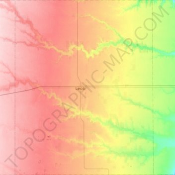
Name: Wichita County topographic map, elevation, terrain.
Location: Wichita County, Kansas, USA (38.26305 -101.56935 38.70038 -101.12540)
Average elevation: 3,294 ft
Minimum elevation: 3,005 ft
Maximum elevation: 3,543 ft
Other topographic maps
Click on a map to view its topography, its elevation and its terrain.
Council Grove Dam
Council Grove Dam, Morris County, Kansas, USA
Average elevation: 1,283 ft
Independence
USA > Kansas > Independence
Independence, Montgomery County, Kansas, 67301, USA
Average elevation: 804 ft