
Anderson County topographic map
Interactive map
Click on the map to display elevation.
About this map
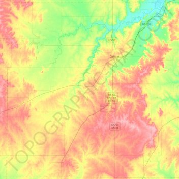
Name: Anderson County topographic map, elevation, terrain.
Location: Anderson County, Kansas, USA (38.03760 -95.51897 38.39047 -95.06233)
Average elevation: 1,050 ft
Minimum elevation: 876 ft
Maximum elevation: 1,217 ft
Other topographic maps
Click on a map to view its topography, its elevation and its terrain.
Council Grove Dam
Council Grove Dam, Morris County, Kansas, USA
Average elevation: 1,283 ft
Independence
USA > Kansas > Independence
Independence, Montgomery County, Kansas, 67301, USA
Average elevation: 804 ft