
Sacedón topographic map
Interactive map
Click on the map to display elevation.
About this map
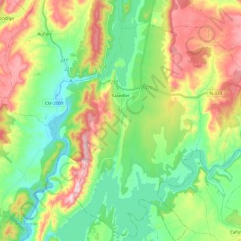
Name: Sacedón topographic map, elevation, terrain.
Location: Sacedón, Guadalajara, Castilla-La Mancha, 19120, España (40.39513 -2.78417 40.53752 -2.63307)
Average elevation: 2,595 ft
Minimum elevation: 2,090 ft
Maximum elevation: 3,481 ft
El relieve del municipio está definido por una zona llana entre dos montañosas, al este la que rodea a la pedanía de Córcoles, que supera los 1000 m de altitud, y al oeste, las primeras estribaciones de la sierra de Altomira, que llegan a los 1063 m en la Peña del Reloj. Estas características geográficas facilitan que se asienten el embalse de Entrepeñas al norte, el embalse de Bolarque al oeste y el de Buendía al sur. La altitud varía entre los 1063 m al suroeste y los 650 m a orillas del embalse de Bolarque. El pueblo se eleva hasta los 740 m sobre el nivel del mar.
Other topographic maps
Click on a map to view its topography, its elevation and its terrain.
Honrubia
Honrubia, Cuenca, Castilla-La Mancha, España
Average elevation: 2,730 ft
San Lorenzo de Calatrava
San Lorenzo de Calatrava, Ciudad Real, Castilla-La Mancha, España
Average elevation: 2,644 ft
Minglanilla
Minglanilla, Cuenca, Castilla-La Mancha, 16260, España
Average elevation: 2,516 ft
Jadraque
Jadraque, Guadalajara, Castilla-La Mancha, 19246, España
Average elevation: 2,933 ft
Albacete
España > Castilla-La Mancha > Albacete
Albacete, Castilla-La Mancha, España
Average elevation: 2,579 ft
Buenaventura
España > Castilla-La Mancha > Buenaventura
Buenaventura, Sierra de San Vicente, Toledo, Castilla-La Mancha, 45634, España
Average elevation: 1,696 ft
Navahermosa
España > Castilla-La Mancha > Navahermosa
Navahermosa, Montes de Toledo, Toledo, Castilla-La Mancha, España
Average elevation: 2,533 ft
Toledo
España > Castilla-La Mancha > Toledo
Toledo, Castilla-La Mancha, España
Average elevation: 1,893 ft
La Herrera
España > Castilla-La Mancha > La Herrera
La Herrera, Albacete, Castilla-La Mancha, España
Average elevation: 2,425 ft
Arroyo de la Dehesa
España > Castilla-La Mancha > Molina de Aragón
Arroyo de la Dehesa, Molina de Aragón, Guadalajara, Castilla-La Mancha, España
Average elevation: 3,865 ft
Cueva del Entradero
España > Castilla-La Mancha > Trillo
Cueva del Entradero, Trillo, Guadalajara, Castilla-La Mancha, España
Average elevation: 2,546 ft
Embalse de Alcorlo
España > Castilla-La Mancha > La Toba
Embalse de Alcorlo, CM-1001, La Toba, Guadalajara, Castilla-La Mancha, España
Average elevation: 3,176 ft
El Pedregal
España > Castilla-La Mancha > El Pedregal > El Pedregal
El Pedregal, Guadalajara, Castilla-La Mancha, 19327, España
Average elevation: 4,032 ft
Tortuera
España > Castilla-La Mancha > Tortuera
Tortuera, Guadalajara, Castilla-La Mancha, España
Average elevation: 3,753 ft
El Llano
España > Castilla-La Mancha > Albacete > San Pedro
El Llano, San Pedro, Albacete, Castilla-La Mancha, 02326, España
Average elevation: 2,792 ft
Pedro González
España > Castilla-La Mancha > Chueca
Pedro González, Chueca, Toledo, Castilla-La Mancha, España
Average elevation: 2,438 ft