Geolocate

Wilson topographic map

Click on the map to display elevation.

About this map

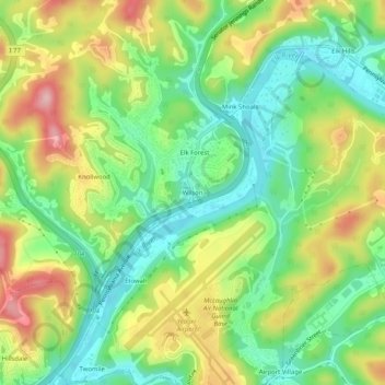
Name: Wilson topographic map, elevation, terrain.

Location: Wilson, Kanawha County, West Virginia, 25302, United States (38.36537 -81.61346 38.40537 -81.57346)

Average elevation: 807 ft

Minimum elevation: 561 ft

Maximum elevation: 1,168 ft

Kanawha County trails, hiking, mountain biking, running and outdoor activities

Other topographic maps

Click on a map to view its topography, its elevation and its terrain.

Nitro

United States > West Virginia > Kanawha County

Average elevation: 722 ft

Coal Fork

United States > West Virginia > Kanawha County

Average elevation: 968 ft

Clendenin

United States > West Virginia > Kanawha County

Average elevation: 860 ft

Gear up for your next adventure:

🧷Carabiner Set - Durable clips for gear attachment
🧥Waterproof Jacket for Hiking - Breathable and rugged rain jacket for outdoor excursions
🧦Merino Wool Socks - Moisture-wicking, blister-preventing socks for long treks
🔊Portable Camp Speaker - Music and alerts at camp
🪄Magnetic Compass - Accurate compass for navigation

As an Amazon Associate, this site earns from qualifying purchases at no extra cost to you.