Geolocate

Frieda River topographic map

Click on the map to display elevation.

About this map

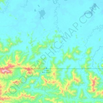
Name: Frieda River topographic map, elevation, terrain.

Location: Frieda River, East Sepik, Momase Region, Papua New Guinea (-4.76085 141.83509 -4.31425 142.03907)

Average elevation: 581 ft

Minimum elevation: 26 ft

Maximum elevation: 4,721 ft

Other topographic maps

Click on a map to view its topography, its elevation and its terrain.

Mount Ambunti

Papua New Guinea > East Sepik > Ambunti

Average elevation: 650 ft

Yangoru

Papua New Guinea > East Sepik

Average elevation: 748 ft

Wewak

Papua New Guinea > East Sepik

Average elevation: 318 ft

Lybia

Papua New Guinea > East Sepik

Average elevation: 1,985 ft

Turubu

Papua New Guinea > East Sepik

Average elevation: 72 ft

Hagama

Papua New Guinea > East Sepik

Average elevation: 486 ft

Mount Turu

Papua New Guinea > East Sepik

Average elevation: 2,799 ft

Sima

Papua New Guinea > East Sepik

Average elevation: 1,483 ft

Lybia

Papua New Guinea > East Sepik

Average elevation: 1,985 ft

Maprik

Papua New Guinea > East Sepik

Average elevation: 705 ft

Ambunti

Papua New Guinea > East Sepik

Average elevation: 187 ft

Gear up for your next adventure:

🌡️Handheld Weather Meters - Measure wind, temp, and pressure for safe mountain travel
🧭Compass with Lanyard - Easy‑carry compass for navigation
🌐World Map Poster - Decorative world maps with topographic info
🧣Merino Neck Gaiters - Multi-functional headwear for wind and sun protection
🪓Survival Multi‑Tool - Versatile tool for camp and trail tasks

As an Amazon Associate, this site earns from qualifying purchases at no extra cost to you.