
Make a donation
Gear up for your next adventure:
As an Amazon Associate, this site earns from qualifying purchases at no extra cost to you.
Capão da Imbuia topographic map
Click on the map to display elevation.
Make a donation
Gear up for your next adventure:
As an Amazon Associate, this site earns from qualifying purchases at no extra cost to you.
About this map
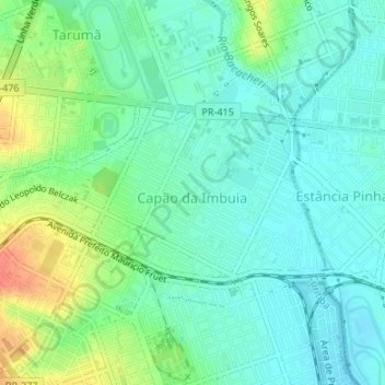
Name: Capão da Imbuia topographic map, elevation, terrain.
Average elevation: 2,930 ft
Minimum elevation: 2,877 ft
Maximum elevation: 3,051 ft
Make a donation
Gear up for your next adventure:
As an Amazon Associate, this site earns from qualifying purchases at no extra cost to you.
Other topographic maps
Click on a map to view its topography, its elevation and its terrain.
Parque Municipal do Passaúna
Brasil > Paraná > Região Metropolitana de Curitiba > Curitiba
Average elevation: 3,009 ft
Rio Água Verde
Brasil > Paraná > Região Metropolitana de Curitiba > Curitiba > Vila Torres
Average elevation: 2,956 ft
Praça Santos Andrade
Brasil > Paraná > Região Metropolitana de Curitiba > Curitiba
Average elevation: 2,986 ft
Make a donation
Gear up for your next adventure:
As an Amazon Associate, this site earns from qualifying purchases at no extra cost to you.
Parque Náutico
Brasil > Paraná > Região Metropolitana de Curitiba > Curitiba
Average elevation: 2,874 ft
Bosque Reinhard Maack
Brasil > Paraná > Região Metropolitana de Curitiba > Curitiba
Average elevation: 2,966 ft
Rio Passaúna
Brasil > Paraná > Região Metropolitana de Curitiba > Curitiba
Average elevation: 3,025 ft
Jardim Botânico de Curitiba
Brasil > Paraná > Região Metropolitana de Curitiba > Curitiba
Average elevation: 2,989 ft
Make a donation
Gear up for your next adventure:
As an Amazon Associate, this site earns from qualifying purchases at no extra cost to you.
Bosque de Portugal
Brasil > Paraná > Região Metropolitana de Curitiba > Curitiba
Average elevation: 2,992 ft
Praça das Nações
Brasil > Paraná > Região Metropolitana de Curitiba > Curitiba
Average elevation: 2,989 ft
Praça Zumbi dos Palmares
Brasil > Paraná > Região Metropolitana de Curitiba > Curitiba
Average elevation: 3,018 ft
Praça Bento Munhoz da Rocha Neto
Brasil > Paraná > Região Metropolitana de Curitiba > Curitiba
Average elevation: 2,995 ft
Make a donation
Gear up for your next adventure:
As an Amazon Associate, this site earns from qualifying purchases at no extra cost to you.
Parque Tingui
Brasil > Paraná > Região Metropolitana de Curitiba > Curitiba
Average elevation: 3,091 ft
Jardinete Osmar Carta
Brasil > Paraná > Região Metropolitana de Curitiba > Curitiba
Average elevation: 3,051 ft