
Make a donation
Gear up for your next adventure:
As an Amazon Associate, this site earns from qualifying purchases at no extra cost to you.
Parque Náutico topographic map
Click on the map to display elevation.
Make a donation
Gear up for your next adventure:
As an Amazon Associate, this site earns from qualifying purchases at no extra cost to you.
About this map
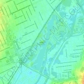
Name: Parque Náutico topographic map, elevation, terrain.
Average elevation: 2,874 ft
Minimum elevation: 2,835 ft
Maximum elevation: 2,956 ft
Make a donation
Gear up for your next adventure:
As an Amazon Associate, this site earns from qualifying purchases at no extra cost to you.
Other topographic maps
Click on a map to view its topography, its elevation and its terrain.
Centro Cívico
Brasil > Paraná > Região Metropolitana de Curitiba > Curitiba
Average elevation: 3,022 ft
Make a donation
Gear up for your next adventure:
As an Amazon Associate, this site earns from qualifying purchases at no extra cost to you.
Capão da Imbuia
Brasil > Paraná > Região Metropolitana de Curitiba > Curitiba
Average elevation: 2,930 ft
Make a donation
Gear up for your next adventure:
As an Amazon Associate, this site earns from qualifying purchases at no extra cost to you.
Alto Boqueirão
Brasil > Paraná > Região Metropolitana de Curitiba > Curitiba
Average elevation: 2,910 ft
Bacia do Rio Iguaçú
Brasil > Paraná > Região Metropolitana de Curitiba > Curitiba > Aldeia Kakane Porã
Average elevation: 2,884 ft
Make a donation
Gear up for your next adventure:
As an Amazon Associate, this site earns from qualifying purchases at no extra cost to you.
Cidade Industrial de Curitiba
Brasil > Paraná > Região Metropolitana de Curitiba > Curitiba
Average elevation: 2,999 ft
Sítio Cercado
Brasil > Paraná > Região Metropolitana de Curitiba > Curitiba
Average elevation: 2,956 ft
Make a donation
Gear up for your next adventure:
As an Amazon Associate, this site earns from qualifying purchases at no extra cost to you.
Make a donation
Gear up for your next adventure:
As an Amazon Associate, this site earns from qualifying purchases at no extra cost to you.
Vista Alegre
Brasil > Paraná > Região Metropolitana de Curitiba > Curitiba
Average elevation: 3,091 ft
São Lourenço
Brasil > Paraná > Região Metropolitana de Curitiba > Curitiba
Average elevation: 3,097 ft
Eixo de Animação Arthur Bernardes
Brasil > Paraná > Região Metropolitana de Curitiba > Curitiba
Average elevation: 3,009 ft
Make a donation
Gear up for your next adventure:
As an Amazon Associate, this site earns from qualifying purchases at no extra cost to you.
Represa Passaúna
Brasil > Paraná > Região Metropolitana de Curitiba > Curitiba
Average elevation: 3,015 ft
Campina do Siqueira
Brasil > Paraná > Região Metropolitana de Curitiba > Curitiba
Average elevation: 3,015 ft
Make a donation
Gear up for your next adventure:
As an Amazon Associate, this site earns from qualifying purchases at no extra cost to you.
Praça Rui Barbosa
Brasil > Paraná > Região Metropolitana de Curitiba > Curitiba
Average elevation: 2,992 ft
Make a donation
Gear up for your next adventure:
As an Amazon Associate, this site earns from qualifying purchases at no extra cost to you.
Campo de Santana
Brasil > Paraná > Região Metropolitana de Curitiba > Curitiba > Aldeia Kakane Porã
Average elevation: 2,917 ft
Santa Quitéria
Brasil > Paraná > Região Metropolitana de Curitiba > Curitiba
Average elevation: 2,992 ft
Make a donation
Gear up for your next adventure:
As an Amazon Associate, this site earns from qualifying purchases at no extra cost to you.
São Francisco
Brasil > Paraná > Região Metropolitana de Curitiba > Curitiba
Average elevation: 3,025 ft
Make a donation
Gear up for your next adventure:
As an Amazon Associate, this site earns from qualifying purchases at no extra cost to you.
Parque Atuba
Brasil > Paraná > Região Metropolitana de Curitiba > Curitiba
Average elevation: 3,005 ft