
Make a donation
Gear up for your next adventure:
As an Amazon Associate, this site earns from qualifying purchases at no extra cost to you.
uMfolozi Local Municipality topographic map
Click on the map to display elevation.
Make a donation
Gear up for your next adventure:
As an Amazon Associate, this site earns from qualifying purchases at no extra cost to you.
About this map
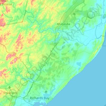
Name: uMfolozi Local Municipality topographic map, elevation, terrain.
Average elevation: 200 ft
Minimum elevation: -3 ft
Maximum elevation: 1,270 ft
Make a donation
Gear up for your next adventure:
As an Amazon Associate, this site earns from qualifying purchases at no extra cost to you.
Other topographic maps
Click on a map to view its topography, its elevation and its terrain.
Nkandla
South Africa > KwaZulu-Natal > King Cetswayo District Municipality > Nkandla Local Municipality
Average elevation: 3,412 ft
Melmoth
South Africa > KwaZulu-Natal > King Cetswayo District Municipality > Mthonjaneni Local Municipality
Average elevation: 2,536 ft
Richards Bay
South Africa > KwaZulu-Natal > King Cetswayo District Municipality
Average elevation: 102 ft
Eshowe
South Africa > KwaZulu-Natal > King Cetswayo District Municipality > uMlalazi Local Municipality
Average elevation: 1,499 ft
Make a donation
Gear up for your next adventure:
As an Amazon Associate, this site earns from qualifying purchases at no extra cost to you.
Empangeni
South Africa > KwaZulu-Natal > King Cetswayo District Municipality > uMhlathuze Local Municipality
Average elevation: 292 ft
Sikhalasenkosi
South Africa > KwaZulu-Natal > King Cetswayo District Municipality > uMhlathuze Local Municipality
Average elevation: 105 ft
Mtunzini
South Africa > KwaZulu-Natal > King Cetswayo District Municipality > uMlalazi Local Municipality
Average elevation: 98 ft
Amatikulu
South Africa > KwaZulu-Natal > King Cetswayo District Municipality > uMlalazi Local Municipality
Average elevation: 177 ft
Make a donation
Gear up for your next adventure:
As an Amazon Associate, this site earns from qualifying purchases at no extra cost to you.
eNtumeni
South Africa > KwaZulu-Natal > King Cetswayo District Municipality > uMlalazi Local Municipality
Average elevation: 2,549 ft
Sikhalasenkosi
South Africa > KwaZulu-Natal > King Cetswayo District Municipality > uMhlathuze Local Municipality
Average elevation: 105 ft
Empangeni
South Africa > KwaZulu-Natal > King Cetswayo District Municipality > uMhlathuze Local Municipality
Average elevation: 292 ft
Empangeni
South Africa > KwaZulu-Natal > King Cetswayo District Municipality > uMhlathuze Local Municipality
Average elevation: 292 ft
Make a donation
Gear up for your next adventure:
As an Amazon Associate, this site earns from qualifying purchases at no extra cost to you.
Eshowe
South Africa > KwaZulu-Natal > King Cetswayo District Municipality > uMlalazi Local Municipality
Average elevation: 1,499 ft
Richards Bay
South Africa > KwaZulu-Natal > King Cetswayo District Municipality
Average elevation: 102 ft
Melmoth
South Africa > KwaZulu-Natal > King Cetswayo District Municipality > Mthonjaneni Local Municipality
Average elevation: 2,536 ft
Melmoth
South Africa > KwaZulu-Natal > King Cetswayo District Municipality > Mthonjaneni Local Municipality
Average elevation: 2,536 ft
Make a donation
Gear up for your next adventure:
As an Amazon Associate, this site earns from qualifying purchases at no extra cost to you.
Mtunzini
South Africa > KwaZulu-Natal > King Cetswayo District Municipality > uMlalazi Local Municipality
Average elevation: 98 ft
Eshowe
South Africa > KwaZulu-Natal > King Cetswayo District Municipality > uMlalazi Local Municipality
Average elevation: 1,499 ft
Richards Bay
South Africa > KwaZulu-Natal > King Cetswayo District Municipality
Average elevation: 102 ft
Richards Bay
South Africa > KwaZulu-Natal > King Cetswayo District Municipality
Average elevation: 102 ft
Make a donation
Gear up for your next adventure:
As an Amazon Associate, this site earns from qualifying purchases at no extra cost to you.