
Make a donation
Gear up for your next adventure:
As an Amazon Associate, this site earns from qualifying purchases at no extra cost to you.
Sathyamangalam WLS/Tiger Reserve topographic map
Click on the map to display elevation.
Make a donation
Gear up for your next adventure:
As an Amazon Associate, this site earns from qualifying purchases at no extra cost to you.
Sathyamangalam WLS/Tiger Reserve
The Sathyamangalam forest is mostly tropical dry forest, part of the South Deccan Plateau dry deciduous forests ecoregion. There are five distinct forest types: tropical evergreen (Shola), semi-evergreen, mixed-deciduous, dry deciduous and thorn forests. Evergreen forests are restricted to small patches in a few high altitude hill tops of Sathyamamgalam between 750 metres (2,460 ft) and 1,649 metres (5,410 ft). These patches are threatened on account of land use changing to hill agriculture and plantation crops, including fruit. Semi-evergreen forests are found at high altitude. Mixed and dry deciduous forests are located on middle altitude slopes and the thorn forests are usually found in the foothills and some times, due degradation of dry deciduous forests, at the middle elevations. About 65% of the forest division is under forest cover. Significant areas of mixed shrubland and grasslands support a large population of herbivore ungulates, the preferred prey of tigers.
Make a donation
Gear up for your next adventure:
As an Amazon Associate, this site earns from qualifying purchases at no extra cost to you.
About this map
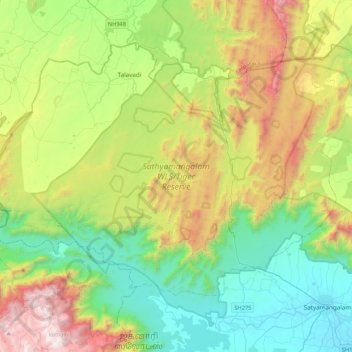
Name: Sathyamangalam WLS/Tiger Reserve topographic map, elevation, terrain.
Average elevation: 2,749 ft
Minimum elevation: 735 ft
Maximum elevation: 6,916 ft
Make a donation
Gear up for your next adventure:
As an Amazon Associate, this site earns from qualifying purchases at no extra cost to you.
Other topographic maps
Click on a map to view its topography, its elevation and its terrain.
Make a donation
Gear up for your next adventure:
As an Amazon Associate, this site earns from qualifying purchases at no extra cost to you.