
Thank you for supporting this site ❤️
Make a donation
Make a donation
Gear up for your next adventure:
As an Amazon Associate, this site earns from qualifying purchases at no extra cost to you.
Curtis topographic map
Click on the map to display elevation.
Thank you for supporting this site ❤️
Make a donation
Make a donation
Gear up for your next adventure:
As an Amazon Associate, this site earns from qualifying purchases at no extra cost to you.
About this map
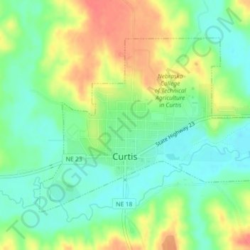
Name: Curtis topographic map, elevation, terrain.
Location: Curtis, Frontier County, Nebraska, 69025, United States (40.62402 -100.52781 40.64289 -100.49611)
Average elevation: 2,615 ft
Minimum elevation: 2,539 ft
Maximum elevation: 2,723 ft
Frontier County trails, hiking, mountain biking, running and outdoor activities
Thank you for supporting this site ❤️
Make a donation
Make a donation
Gear up for your next adventure:
As an Amazon Associate, this site earns from qualifying purchases at no extra cost to you.