Geolocate

Merom topographic map

Click on the map to display elevation.

About this map
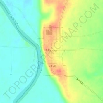
Name: Merom topographic map, elevation, terrain.

Location: Merom, Sullivan County, Indiana, United States (39.04965 -87.57245 39.06258 -87.56257)

Average elevation: 489 ft

Minimum elevation: 413 ft

Maximum elevation: 604 ft

Sullivan County trails, hiking, mountain biking, running and outdoor activities

Other topographic maps

Click on a map to view its topography, its elevation and its terrain.
Bucktown

United States > Indiana > Sullivan County

Average elevation: 548 ft

Fairbanks

United States > Indiana > Sullivan County

Average elevation: 538 ft

Gear up for your next adventure:

👟Trail Running Shoes - Lightweight shoes for trail runners
⛑️Personal Locator Beacon - Safety beacon for emergencies
🔦Powerful Headlamps - Ultra-bright hands-free lighting for night navigation
🔥Fast-Boil Camping Stoves - Efficient cooking systems for quick trail meals
📶Satellite Messenger - Communication device off‑grid

As an Amazon Associate, this site earns from qualifying purchases at no extra cost to you.