Geolocate

Fairbanks topographic map

Click on the map to display elevation.

About this map

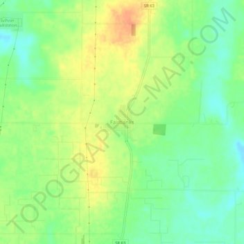
Name: Fairbanks topographic map, elevation, terrain.

Location: Fairbanks, Sullivan County, Indiana, 47849, United States (39.19948 -87.54224 39.23948 -87.50224)

Average elevation: 538 ft

Minimum elevation: 479 ft

Maximum elevation: 604 ft

Other topographic maps

Click on a map to view its topography, its elevation and its terrain.

Dugger

United States > Indiana > Sullivan County

Average elevation: 571 ft

Merom

United States > Indiana > Sullivan County

Average elevation: 489 ft

Shelburn

United States > Indiana > Sullivan County

Average elevation: 538 ft

Carlisle

United States > Indiana > Sullivan County

Average elevation: 515 ft

Gear up for your next adventure:

🧴Hand Sanitizer - Keep hands clean while hiking
🌲Outdoor Survival Books - Best books on survival skills
🔥Plasma Lighters - Windproof lighters that work in any weather condition
❄️Traction Cleats - Prevent slips on icy trails during winter hikes
🪶Trail Camera - Capture wildlife on your hikes

As an Amazon Associate, this site earns from qualifying purchases at no extra cost to you.