Geolocate

Merom topographic map

Click on the map to display elevation.

About this map

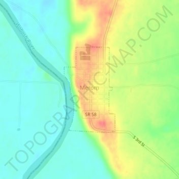
Name: Merom topographic map, elevation, terrain.

Location: Merom, Sullivan County, Indiana, United States (39.04965 -87.57245 39.06258 -87.56257)

Average elevation: 489 ft

Minimum elevation: 413 ft

Maximum elevation: 604 ft

Sullivan County trails, hiking, mountain biking, running and outdoor activities

Other topographic maps

Click on a map to view its topography, its elevation and its terrain.

Bucktown

United States > Indiana > Sullivan County

Average elevation: 548 ft

Fairbanks

United States > Indiana > Sullivan County

Average elevation: 538 ft

Gear up for your next adventure:

🗻Climbing Gear Basics - Essential gear for beginner climbers
🦶Hiking Gaiters - Keep debris and water out of your boots
🪶Survival Guide Book - Expert advice for emergency preparedness
🪶LED Camping Lantern - Bright lantern for camp lighting
📷Action Cameras - Rugged cameras to document your journeys across rugged terrain

As an Amazon Associate, this site earns from qualifying purchases at no extra cost to you.