Geolocate

Aneto topographic map

Click on the map to display elevation.

About this map

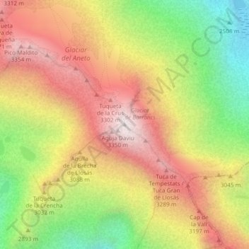
Name: Aneto topographic map, elevation, terrain.

Location: Aneto, Ribagorza, Huesca, Aragon, 22487, Spain (42.63102 0.65660 42.63112 0.65670)

Average elevation: 9,596 ft

Minimum elevation: 7,802 ft

Maximum elevation: 11,171 ft

Other topographic maps

Click on a map to view its topography, its elevation and its terrain.

Capella

Spain > Aragon > Ribagorza

Average elevation: 2,316 ft

Isábena

Spain > Aragon > Ribagorza

Average elevation: 3,366 ft

Capella

Spain > Aragon > Ribagorza

Average elevation: 2,316 ft

Capella

Spain > Aragon > Ribagorza

Average elevation: 2,044 ft

Gear up for your next adventure:

🥾Women's Hiking Boots - Top-rated trail boots with ankle support and superior grip
🕶️GPS Smartphone Mount - Secure mount for phone navigation
🌡️Portable Weather Meter - Track weather conditions on the trail
📷Action Cameras - Rugged cameras to document your journeys across rugged terrain
🧯Portable Fire Pit - Compact fire pit for camping spots

As an Amazon Associate, this site earns from qualifying purchases at no extra cost to you.