Geolocate

Capella topographic map

Click on the map to display elevation.

About this map

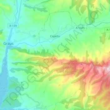
Name: Capella topographic map, elevation, terrain.

Location: Capella, Ribagorza, Huesca, Aragon, Spain (42.13901 0.35960 42.21927 0.49501)

Average elevation: 2,316 ft

Minimum elevation: 1,535 ft

Maximum elevation: 3,760 ft

Other topographic maps

Click on a map to view its topography, its elevation and its terrain.

Tuca de Vallibierna / Roca Bllanca

Spain > Aragon > Ribagorza

Average elevation: 8,504 ft

Aneto

Spain > Aragon > Ribagorza

Average elevation: 9,596 ft

Aneto

Spain > Aragon > Ribagorza

Average elevation: 9,596 ft

Serraduy

Spain > Aragon > Ribagorza

Average elevation: 3,114 ft

Gear up for your next adventure:

🧦Merino Wool Socks - Moisture-wicking, blister-preventing socks for long treks
🦺Reflective Outdoor Gear - Safety gear for low‑light conditions
🚗GPS Dash Cams - Record your scenic drives through mountain passes and canyons
🧭Compass with Lanyard - Easy‑carry compass for navigation
👟Men's Trail Runners - Lightweight footwear for fast-paced exploration and light hiking

As an Amazon Associate, this site earns from qualifying purchases at no extra cost to you.