Geolocate

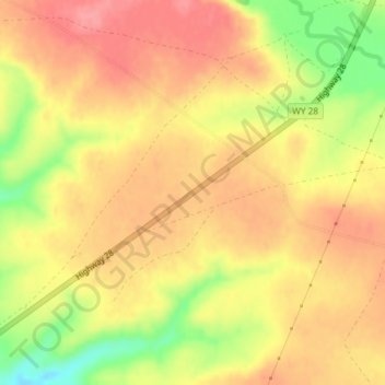
South Pass topographic map

Click on the map to display elevation.

South Pass

South Pass (elevation 7,412 ft (2,259 m) and 7,550 ft (2,300 m)) is a route across the Continental Divide, in the Rocky Mountains in southwestern Wyoming. It lies in a broad high region, 35 miles (56 km) wide, between the nearly 14,000 ft (4,300 m) Wind River Range to the north and the over 8,500 ft (2,600 m) Oregon Buttes and arid, saline near-impassable Great Divide Basin to the south. The Pass lies in southwestern Fremont County, approximately 35 miles (56 km) SSW of Lander.

Wikipedia (CC-BY-SA 3.0)

About this map

Name: South Pass topographic map, elevation, terrain.

Location: South Pass, Fremont County, Wyoming, United States (42.36964 -108.91365 42.36974 -108.91355)

Average elevation: 7,530 ft

Minimum elevation: 7,352 ft

Maximum elevation: 7,628 ft

Fremont County trails, hiking, mountain biking, running and outdoor activities

Other topographic maps

Click on a map to view its topography, its elevation and its terrain.
Pavillion

United States > Wyoming > Fremont County

Average elevation: 5,463 ft

Fort Washakie

United States > Wyoming > Fremont County

Average elevation: 5,715 ft

Arapahoe

United States > Wyoming > Fremont County

Average elevation: 5,102 ft

Horse Creek

United States > Wyoming > Fremont County > Dubois

Average elevation: 7,119 ft

Dinwoody Lake

United States > Wyoming > Fremont County

Average elevation: 6,804 ft

Boysen State Park

United States > Wyoming > Fremont County > Shoshoni

Average elevation: 5,095 ft

Gear up for your next adventure:

🥤Water Filter Bottle - All‑in‑one filter bottle for safe hydration
🧭Hiking Compass - Precision compass for reliable navigation in the wilderness
🧭Map Reading Tools - Tools and kits for map navigation
📚USA Hiking Guide Books - Top trail guides and map books
🔦LED Headlamp - Bright and durable LED headlamp for night navigation

As an Amazon Associate, this site earns from qualifying purchases at no extra cost to you.