
Richmond topographic map
Click on the map to display elevation.
About this map
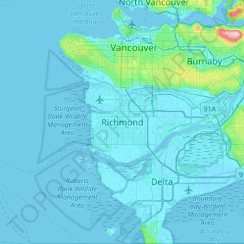
Name: Richmond topographic map, elevation, terrain.
Average elevation: 49 ft
Minimum elevation: -13 ft
Maximum elevation: 1,224 ft
Other topographic maps
Click on a map to view its topography, its elevation and its terrain.
Sea Island
Canada > British Columbia > Metro Vancouver Regional District > Richmond
Average elevation: 20 ft
Finn Slough
Canada > British Columbia > Metro Vancouver Regional District > Richmond
Average elevation: 7 ft
Steveston
Canada > British Columbia > Metro Vancouver Regional District > Richmond
Average elevation: 7 ft
West Cambie
Canada > British Columbia > Metro Vancouver Regional District > Richmond
Average elevation: 10 ft
Fraser River (North Arm)
Canada > British Columbia > Metro Vancouver Regional District > Richmond
Average elevation: 89 ft
Ketcheson Neighbourhood Park
Canada > British Columbia > Metro Vancouver Regional District > Richmond
Average elevation: 10 ft
Mitchell Island
Canada > British Columbia > Metro Vancouver Regional District > Richmond
Average elevation: 46 ft
West Cambie
Canada > British Columbia > Metro Vancouver Regional District > Richmond
Average elevation: 10 ft