
Make a donation
Gear up for your next adventure:
As an Amazon Associate, this site earns from qualifying purchases at no extra cost to you.
Jersey City topographic map
Click on the map to display elevation.
Make a donation
Gear up for your next adventure:
As an Amazon Associate, this site earns from qualifying purchases at no extra cost to you.
Jersey City
Jersey City has a varied topography shaped by its coastal and urban setting along the lower Hudson River. This area, largely at low elevation, sits mostly around 20 feet above sea level, with extensive flatlands near the riverbanks but modest rises inland, leading to subtle hills within the city's dense urban grid. Bordering the Hudson River on its east side, Jersey City's terrain includes a combination of reclaimed waterfront and natural lowlands, resulting in areas prone to flooding, especially during high tides and storms. The city's western areas slope gently upward toward the Palisades, a line of steep cliffs formed by ancient geological activity. This elevated area provides slight relief from the otherwise level surroundings, offering views across the river toward Manhattan and accommodating residential neighborhoods nestled on its slopes. Hudson County’s compact size and dense development contribute to an urban "heat island" effect, where the city’s hard surfaces retain more heat than surrounding suburban or rural regions, impacting local weather and air quality. These topographical elements reflect Jersey City’s mix of natural and human-made landscapes, as well as its strong coastal influence and vulnerability to coastal weather impacts.
Make a donation
Gear up for your next adventure:
As an Amazon Associate, this site earns from qualifying purchases at no extra cost to you.
About this map
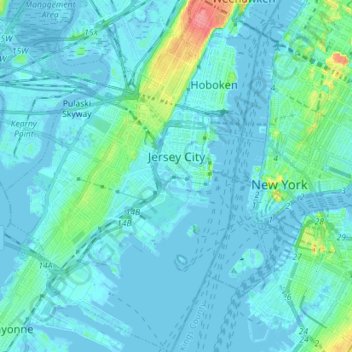
Name: Jersey City topographic map, elevation, terrain.
Location: Jersey City, Hudson County, New Jersey, United States (40.66162 -74.11669 40.76894 -74.02064)
Average elevation: 30 ft
Minimum elevation: -26 ft
Maximum elevation: 262 ft
Hudson County trails, hiking, mountain biking, running and outdoor activities
Make a donation
Gear up for your next adventure:
As an Amazon Associate, this site earns from qualifying purchases at no extra cost to you.
Other topographic maps
Click on a map to view its topography, its elevation and its terrain.
Croxton
United States > New Jersey > Hudson County > Jersey City > Journal Square
Average elevation: 52 ft
Make a donation
Gear up for your next adventure:
As an Amazon Associate, this site earns from qualifying purchases at no extra cost to you.
North Hudson Park
United States > New Jersey > Hudson County > North Bergen > Hudson Heights
Average elevation: 135 ft
Ellis Island
United States > New Jersey > Hudson County > Jersey City > Communipaw
The first floor contained detention rooms, social service offices, and waiting rooms on its west wing, a use that remained relatively unchanged. The central space was initially a baggage room until 1907, but was subsequently subdivided and later re-combined into a single records room. The first floor's east…
Average elevation: 3 ft
Make a donation
Gear up for your next adventure:
As an Amazon Associate, this site earns from qualifying purchases at no extra cost to you.
Bergen Square
United States > New Jersey > Hudson County > Jersey City > Journal Square
Average elevation: 43 ft
Marion
United States > New Jersey > Hudson County > Jersey City > Journal Square
Average elevation: 39 ft
Make a donation
Gear up for your next adventure:
As an Amazon Associate, this site earns from qualifying purchases at no extra cost to you.
Make a donation
Gear up for your next adventure:
As an Amazon Associate, this site earns from qualifying purchases at no extra cost to you.
Croxton
United States > New Jersey > Hudson County > Jersey City > Journal Square
Average elevation: 52 ft
Bergen Square
United States > New Jersey > Hudson County > Jersey City > Journal Square
Average elevation: 43 ft
Hudson River Waterfront
United States > New Jersey > Hudson County > Jersey City
Average elevation: 7 ft
North End Business District
United States > New Jersey > Hudson County > Secaucus
Average elevation: 13 ft
Make a donation
Gear up for your next adventure:
As an Amazon Associate, this site earns from qualifying purchases at no extra cost to you.