
Korongulla topographic map
Click on the map to display elevation.
About this map
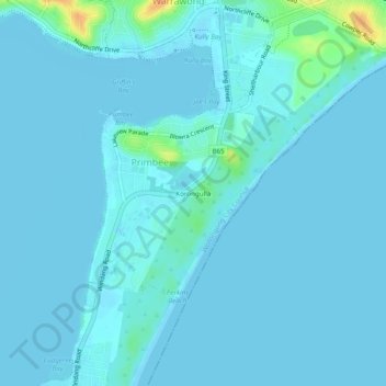
Name: Korongulla topographic map, elevation, terrain.
Average elevation: 10 ft
Minimum elevation: -3 ft
Maximum elevation: 128 ft
Other topographic maps
Click on a map to view its topography, its elevation and its terrain.
Illawarra Escarpment State Conservation Area
Australia > New South Wales > Wollongong City Council > Corrimal
Average elevation: 531 ft
Lake Illawarra
Australia > New South Wales > Wollongong City Council > Yallah
Average elevation: 20 ft
Lake Illawarra
Australia > New South Wales > Wollongong City Council > Yallah
Average elevation: 20 ft