Geolocate

Cataract topographic map

Click on the map to display elevation.

About this map

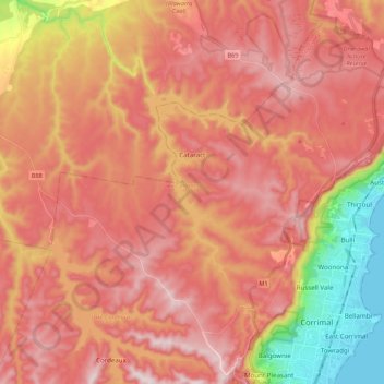
Name: Cataract topographic map, elevation, terrain.

Location: Cataract, Wollongong City Council, New South Wales, 2560, Australia (-34.39527 150.71878 -34.22640 150.93452)

Average elevation: 994 ft

Minimum elevation: 0 ft

Maximum elevation: 1,585 ft

Other topographic maps

Click on a map to view its topography, its elevation and its terrain.

Gear up for your next adventure:

🦶Carbon Trekking Poles - Reduce knee impact on steep descents with ultra-light poles
🧺Microfiber Travel Towels - Compact and fast-drying towels for trail use
🛠️Outdoor Gear Repair Kit - Essential tools to fix gear on the trail
📱Solar Portable Charger - Solar power bank for charging devices off‑grid
🪶Wildlife Field Guides - Learn animal tracking and species ID

As an Amazon Associate, this site earns from qualifying purchases at no extra cost to you.