Geolocate

Dhading Besi topographic map

Click on the map to display elevation.

Dhading Besi

It is at 27°54'45.9"N 84°53'46.2"E at an altitude of 612 metres.

Wikipedia (CC-BY-SA 3.0)

About this map

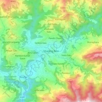
Name: Dhading Besi topographic map, elevation, terrain.

Location: Dhading Besi, Nilakantha, Dhading, Bagamati Province, Nepal (27.87089 84.85528 27.95089 84.93528)

Average elevation: 2,864 ft

Minimum elevation: 1,617 ft

Maximum elevation: 5,213 ft

Other topographic maps

Click on a map to view its topography, its elevation and its terrain.

Netrawati Dabjong

Nepal > Bagamati Province > Dhading

Average elevation: 3,842 ft

Nilakantha

Nepal > Bagamati Province > Dhading

Average elevation: 3,363 ft

Gangajamuna

Nepal > Bagamati Province > Dhading

Average elevation: 4,961 ft

Gear up for your next adventure:

🎒Gear Packing Cubes - Organize your backpack efficiently
🔥Fast-Boil Camping Stoves - Efficient cooking systems for quick trail meals
🧭Pro Hiking Compasses - High-accuracy liquid-filled compasses for topographic orientation
🥾Hiking Shoes - Durable and comfortable shoes for trail hiking
🦶Carbon Trekking Poles - Reduce knee impact on steep descents with ultra-light poles

As an Amazon Associate, this site earns from qualifying purchases at no extra cost to you.