
Deighton topographic map
Click on the map to display elevation.
About this map
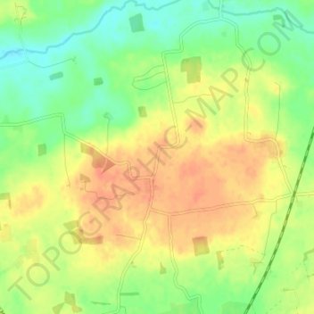
Name: Deighton topographic map, elevation, terrain.
Average elevation: 210 ft
Minimum elevation: 141 ft
Maximum elevation: 272 ft
Other topographic maps
Click on a map to view its topography, its elevation and its terrain.
Bolton Castle
United Kingdom > England > North Yorkshire > Redmire > Castle Bolton
Average elevation: 820 ft
Thimbleby & Osmotherly Show field
United Kingdom > England > North Yorkshire > Thimbleby
Average elevation: 499 ft
Easby Moor
United Kingdom > England > North Yorkshire > Easby > Little Ayton
Average elevation: 604 ft
Killinghall
United Kingdom > England > North Yorkshire > Harrogate > Killinghall
Average elevation: 282 ft
Willerby Brow Plantation
United Kingdom > England > North Yorkshire > Ryedale > Staxton > Binnington
Average elevation: 328 ft