
Make a donation
Gear up for your next adventure:
As an Amazon Associate, this site earns from qualifying purchases at no extra cost to you.
Sankt Goarshausen topographic map
Click on the map to display elevation.
Make a donation
Gear up for your next adventure:
As an Amazon Associate, this site earns from qualifying purchases at no extra cost to you.
Sankt Goarshausen
Der neue rechtsrheinische Wanderweg, der von Bonn bis Wiesbaden über die Höhen des Rheintales führt, der Rheinsteig, geht durch Sankt Goarshausen und über die Loreley, ebenso wie der Rheinhöhenweg. Deswegen bietet sich die Stadt als Zwischenstopp für Wanderer an.
Make a donation
Gear up for your next adventure:
As an Amazon Associate, this site earns from qualifying purchases at no extra cost to you.
About this map
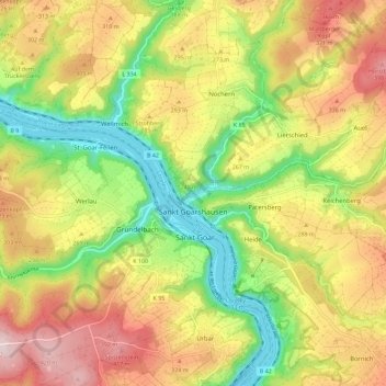
Name: Sankt Goarshausen topographic map, elevation, terrain.
Average elevation: 814 ft
Minimum elevation: 217 ft
Maximum elevation: 1,450 ft
Make a donation
Gear up for your next adventure:
As an Amazon Associate, this site earns from qualifying purchases at no extra cost to you.
Other topographic maps
Click on a map to view its topography, its elevation and its terrain.
Marksburg
Deutschland > Rheinland-Pfalz > Rhein-Lahn-Kreis > Braubach
Die Marksburg ist eine aus dem 12. Jahrhundert stammende Höhenburg oberhalb der rheinland-pfälzischen Stadt Braubach am Rhein, von der sie ihren ursprünglichen Namen Burg Brubach bezog. Sie steht auf einem Schieferkegel in 160 Meter Höhe und ist die einzige nie zerstörte mittelalterliche Höhenburg am…
Average elevation: 486 ft
Wellmich
Deutschland > Rheinland-Pfalz > Rhein-Lahn-Kreis > Sankt Goarshausen
Zu den Gewässern bei Wellmich zählen der Rhein und der Wellmicher Bach. Die Hochwassergefahr durch den Rhein für Wellmich ist gering, da der Ort relativ hoch liegt. Durch den Wellmicher Bach kam es während der Unwetter in Europa im Frühjahr 2016 zu einer Überflutung. Das Wasser des Baches zerstörte…
Average elevation: 692 ft
Niederneisen
Deutschland > Rheinland-Pfalz > Rhein-Lahn-Kreis > Niederneisen > Niederneisen
Durch Niederneisen führen der Wanderweg Aar-Höhenweg und der Rad- und Wanderweg Aartal-Radweg.
Average elevation: 600 ft
Make a donation
Gear up for your next adventure:
As an Amazon Associate, this site earns from qualifying purchases at no extra cost to you.
Lahn
Deutschland > Rheinland-Pfalz > Rhein-Lahn-Kreis > Fachbach > Auf der Oberau
Average elevation: 689 ft
Make a donation
Gear up for your next adventure:
As an Amazon Associate, this site earns from qualifying purchases at no extra cost to you.
Make a donation
Gear up for your next adventure:
As an Amazon Associate, this site earns from qualifying purchases at no extra cost to you.
Make a donation
Gear up for your next adventure:
As an Amazon Associate, this site earns from qualifying purchases at no extra cost to you.
Kurpark Bismarckhöhe
Deutschland > Rheinland-Pfalz > Rhein-Lahn-Kreis > Bad Ems
Average elevation: 702 ft
Lahn
Deutschland > Rheinland-Pfalz > Rhein-Lahn-Kreis > Fachbach > Auf der Oberau
Average elevation: 702 ft
Dörnberg
Deutschland > Rheinland-Pfalz > Rhein-Lahn-Kreis > Dörnberg > Dörnberg
Average elevation: 758 ft
Make a donation
Gear up for your next adventure:
As an Amazon Associate, this site earns from qualifying purchases at no extra cost to you.
Bergnassau-Scheuern
Deutschland > Rheinland-Pfalz > Rhein-Lahn-Kreis > Nassau
Average elevation: 715 ft
Hambach
Deutschland > Rheinland-Pfalz > Rhein-Lahn-Kreis > Hambach > Hambach
Average elevation: 735 ft
Make a donation
Gear up for your next adventure:
As an Amazon Associate, this site earns from qualifying purchases at no extra cost to you.
Schloß Schaumburg
Deutschland > Rheinland-Pfalz > Rhein-Lahn-Kreis > Balduinstein > Schaumburg
Schloss Schaumburg, kurz auch die Schaumburg genannt, ist ein Schloss südlich von Balduinstein nahe Limburg an der Lahn. Ursprünglich war die Anlage eine Höhenburg. Auf ihrem Hauptturm befindet sich der Nullpunkt des Soldner-Koordinatensystems für das Herzogtum Nassau.
Average elevation: 781 ft
Hasenberg
Deutschland > Rheinland-Pfalz > Rhein-Lahn-Kreis > Sankt Goarshausen > Heide
Average elevation: 653 ft