
Kfar Hay topographic map
Click on the map to display elevation.
About this map
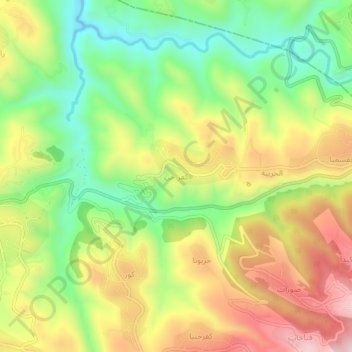
Name: Kfar Hay topographic map, elevation, terrain.
Location: Kfar Hay, Batroun District, North Governorate, 4201, Lebanon (34.22919 35.72299 34.26919 35.76299)
Average elevation: 1,102 ft
Minimum elevation: 400 ft
Maximum elevation: 1,936 ft
Other topographic maps
Click on a map to view its topography, its elevation and its terrain.
Miniyeh
Miniyeh (Arabic: المنية, French: Minieh) is the capital of the Miniyeh-Danniyeh District in North Governorate of Lebanon. Minya is located 96 km from Beirut at an altitude of 20 m above sea level.
Average elevation: 98 ft