
Chekka topographic map
Click on the map to display elevation.
About this map
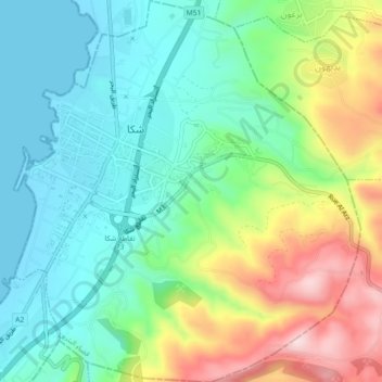
Name: Chekka topographic map, elevation, terrain.
Location: Chekka, Batroun District, North Governorate, Lebanon (34.30621 35.72076 34.34331 35.76159)
Average elevation: 361 ft
Minimum elevation: -7 ft
Maximum elevation: 1,109 ft
Other topographic maps
Click on a map to view its topography, its elevation and its terrain.
Ehden
Ehden is located in the central northern side of Mount Lebanon, with a 1500-metre (at Midan square) elevation from sea level. It is 120 kilometres (75 mi) from Beirut, 30 kilometres (19 mi) from Tripoli and 25 kilometres (16 mi) from Zgharta. Ehden used to be the sole residence for Zghartians prior to the…
Average elevation: 4,429 ft
Tannourine
Tannourine is the plural of the Syriac word tannour, which indicates an old stone oven. Tannourine's name may in fact stem from the local topography, which resembles the convex form of an oven called tannour, with the dual suffix ine as a reference to the two distinct areas of Tannourine Al-Tahta (literally…
Average elevation: 5,253 ft