Geolocate

Gustine topographic map

Click on the map to display elevation.

About this map

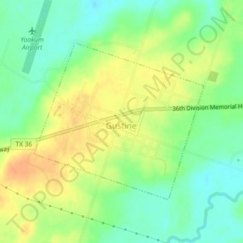
Name: Gustine topographic map, elevation, terrain.

Location: Gustine, Comanche County, Texas, 76455, United States (31.83688 -98.41425 31.85434 -98.39200)

Average elevation: 1,158 ft

Minimum elevation: 1,096 ft

Maximum elevation: 1,224 ft

Comanche County trails, hiking, mountain biking, running and outdoor activities

Other topographic maps

Click on a map to view its topography, its elevation and its terrain.

Energy

United States > Texas > Comanche County

Average elevation: 1,391 ft

Sidney

United States > Texas > Comanche County

Average elevation: 1,450 ft

Gear up for your next adventure:

Backpacking Tent - Lightweight and durable tent for multi‑day hikes
🎒Outdoor Daypacks - Lightweight backpacks designed for carrying maps and essential gear
🪶Survival Guide Book - Expert advice for emergency preparedness
🌎3D Topographic Globes - Raised relief globes for a tactile understanding of geography
💧Water Purification System - Clean water on the trail with reliable purifiers

As an Amazon Associate, this site earns from qualifying purchases at no extra cost to you.