
Deadman's Island topographic map
Interactive map
Click on the map to display elevation.
About this map
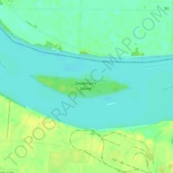
Name: Deadman's Island topographic map, elevation, terrain.
Location: Deadman's Island, Henderson County, Kentucky, USA (37.82040 -87.66867 37.82382 -87.64876)
Average elevation: 367 ft
Minimum elevation: 338 ft
Maximum elevation: 413 ft
Other topographic maps
Click on a map to view its topography, its elevation and its terrain.
Forest Hills
USA > Kentucky > Forest Hills
Forest Hills, Jefferson County, Kentucky, USA
Average elevation: 663 ft
Mammoth Cave
USA > Kentucky > Mammoth Cave
Mammoth Cave, Edmonson County, Kentucky, USA
Average elevation: 702 ft
Stephens Lake
Stephens Lake, Hicks Road, Beelerton, Hickman County, Kentucky, 42085, USA
Average elevation: 367 ft
Murray Hill
USA > Kentucky > Murray Hill
Murray Hill, Jefferson County, Kentucky, USA
Average elevation: 636 ft
Georgetown
USA > Kentucky > Georgetown
Georgetown, Scott County, Kentucky, 40324, USA
Average elevation: 869 ft