
Hopkins County topographic map
Interactive map
Click on the map to display elevation.
About this map
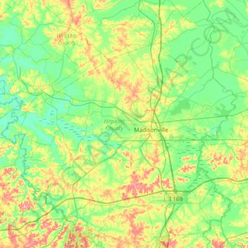
Name: Hopkins County topographic map, elevation, terrain.
Location: Hopkins County, Kentucky, United States (37.10516 -87.85183 37.57006 -87.29575)
Average elevation: 440 ft
Minimum elevation: 328 ft
Maximum elevation: 719 ft
The topography ranges from flatlands along the broad river valleys of the Pond River, Tradewater River, and Green River, to hilly and rolling land in the southern and central parts of the county. Coal mines operate in the southern part of Hopkins County and agriculture is a mainstay in the northern part. Major crops are soybeans, corn, and tobacco. Along with coal, resources include oil and natural gas.
Other topographic maps
Click on a map to view its topography, its elevation and its terrain.
Fort Knox
United States > Kentucky > Fort Knox
Fort Knox, Hardin County, Kentucky, 40121, United States
Average elevation: 682 ft
Bowling Green
United States > Kentucky > Warren County
Bowling Green, Warren County, Kentucky, 42101, United States
Average elevation: 554 ft
Louisville
United States > Kentucky > Jefferson County
Louisville, Jefferson County, Kentucky, United States
Average elevation: 617 ft
Owensboro
United States > Kentucky > Daviess County
Owensboro, Daviess County, Kentucky, United States
Average elevation: 404 ft
Somerset
United States > Kentucky > Pulaski County
Somerset, Pulaski County, Kentucky, 42503, United States
Average elevation: 968 ft
Frankfort
United States > Kentucky > Franklin County
Frankfort, Franklin County, Kentucky, United States
Average elevation: 709 ft
Paducah
United States > Kentucky > McCracken County
Paducah, McCracken County, Kentucky, United States
Average elevation: 354 ft
Land Between the Lakes National Recreation Area
United States > Kentucky > Trigg County
Land Between the Lakes National Recreation Area, Trigg County, Kentucky, United States
Average elevation: 479 ft
Radcliffe
United States > Kentucky > Fayette County > Lexington
Radcliffe, Radcliff Marlboro, Lexington, Fayette County, Kentucky, 40505, United States
Average elevation: 978 ft
Liberty
United States > Kentucky > Casey County
Liberty, Casey County, Kentucky, United States
Average elevation: 906 ft
Lexington
United States > Kentucky > Lexington
Lexington, Fayette County, Kentucky, 40508, United States
Average elevation: 935 ft
McHenry
United States > Kentucky > Ohio County
McHenry, Ohio County, Kentucky, 42354, United States
Average elevation: 466 ft
Tollesboro
United States > Kentucky > Lewis County
Tollesboro, Lewis County, Kentucky, 41189, United States
Average elevation: 784 ft
Cordell
United States > Kentucky > Lawrence County
Cordell, Lawrence County, Kentucky, United States
Average elevation: 906 ft
Breckinridge County
Breckinridge County, Kentucky, United States
Average elevation: 627 ft
Hardinsburg
United States > Kentucky > Breckinridge County
Hardinsburg, Breckinridge County, Kentucky, 40143, United States
Average elevation: 673 ft
Guthrie
United States > Kentucky > Todd County
Guthrie, Todd County, Kentucky, United States
Average elevation: 564 ft
Southville
United States > Kentucky > Shelby County
Southville, Shelby County, Kentucky, United States
Average elevation: 758 ft
Shakertown
United States > Kentucky > Mercer County
Shakertown, Mercer County, Kentucky, United States
Average elevation: 827 ft
Straw
United States > Kentucky > Edmonson County
Straw, Edmonson County, Kentucky, 42259, United States
Average elevation: 738 ft
Vine Grove
United States > Kentucky > Hardin County
Vine Grove, Hardin County, Kentucky, United States
Average elevation: 715 ft
Wickliffe
United States > Kentucky > Ballard County
Wickliffe, Ballard County, Kentucky, United States
Average elevation: 361 ft
Francisville
United States > Kentucky > Boone County
Francisville, Boone County, Kentucky, 41048, United States
Average elevation: 751 ft
Lebanon Junction
United States > Kentucky > Bullitt County
Lebanon Junction, Bullitt County, Kentucky, United States
Average elevation: 472 ft
Bradley
United States > Kentucky > Magoffin County
Bradley, Magoffin County, Kentucky, United States
Average elevation: 1,073 ft
Lexington
United States > Kentucky > Fayette County
Lexington, Fayette County, Kentucky, United States
Average elevation: 922 ft
Buzzard Roost
United States > Kentucky > Calloway County
Buzzard Roost, Calloway County, Kentucky, United States
Average elevation: 459 ft
Springfield
United States > Kentucky > Washington County
Springfield, Washington County, Kentucky, United States
Average elevation: 797 ft
Daviess County
Daviess County, Kentucky, United States
Average elevation: 427 ft
Knoxville
United States > Kentucky > Pendleton County
Knoxville, Pendleton County, Kentucky, United States
Average elevation: 823 ft
Ezel
United States > Kentucky > Morgan County
Ezel, Morgan County, Kentucky, 41425, United States
Average elevation: 958 ft
Sullivan
United States > Kentucky > Union County
Sullivan, Union County, Kentucky, 42460, United States
Average elevation: 387 ft
Fayette County
Fayette County, Kentucky, United States
Average elevation: 925 ft
Van Cleave
United States > Kentucky > Calloway County
Van Cleave, Calloway County, Kentucky, 42091, United States
Average elevation: 528 ft
Gilbertsville
United States > Kentucky > Marshall County
Gilbertsville, Marshall County, Kentucky, United States
Average elevation: 341 ft
Vealsburg
United States > Kentucky > Graves County
Vealsburg, Graves County, Kentucky, 42040, United States
Average elevation: 528 ft
Carrollton
United States > Kentucky > Carroll County
Carrollton, Carroll County, Kentucky, United States
Average elevation: 558 ft
Cumberland Falls
United States > Kentucky > McCreary County
Cumberland Falls, McCreary County, Kentucky, 42634, United States
Average elevation: 1,024 ft
Madisonville
United States > Kentucky > Hopkins County
Madisonville, Hopkins County, Kentucky, 42431, United States
Average elevation: 446 ft
Timsley
United States > Kentucky > Bell County
Timsley, Bell County, Kentucky, 40939, United States
Average elevation: 1,358 ft
Southgate
United States > Kentucky > Campbell County
Southgate, Campbell County, Kentucky, United States
Average elevation: 696 ft
Hickman County
Hickman County, Kentucky, United States
Average elevation: 381 ft
Frenchburg
United States > Kentucky > Menifee County
Frenchburg, Menifee County, Kentucky, United States
Average elevation: 1,083 ft
Kentucky River
Kentucky River, Kentucky, United States
Average elevation: 853 ft
Hargis
United States > Kentucky > Pulaski County
Hargis, Pulaski County, Kentucky, United States
Average elevation: 928 ft
Elliott County
Elliott County, Kentucky, United States
Average elevation: 912 ft
Alberta
United States > Kentucky > Scott County
Alberta, Scott County, Kentucky, United States
Average elevation: 912 ft