Geolocate

Warnock topographic map

Click on the map to display elevation.

About this map

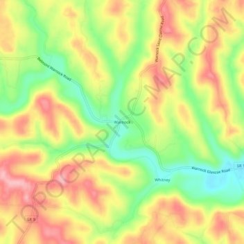
Name: Warnock topographic map, elevation, terrain.

Location: Warnock, Belmont County, Ohio, 43967, United States (40.00257 -80.95732 40.04257 -80.91732)

Average elevation: 1,106 ft

Minimum elevation: 860 ft

Maximum elevation: 1,325 ft

Belmont County trails, hiking, mountain biking, running and outdoor activities

Other topographic maps

Click on a map to view its topography, its elevation and its terrain.

Neffs

United States > Ohio > Belmont County > Neffs

Average elevation: 984 ft

Morristown

United States > Ohio > Belmont County

Average elevation: 1,227 ft

Flushing

United States > Ohio > Belmont County

Average elevation: 1,198 ft

Holloway

United States > Ohio > Belmont County

Average elevation: 1,027 ft

Brookside

United States > Ohio > Belmont County

Average elevation: 922 ft

Bridgeport

United States > Ohio > Belmont County

Average elevation: 801 ft

Bethesda

United States > Ohio > Belmont County

Average elevation: 1,234 ft

Belmont

United States > Ohio > Belmont County

Average elevation: 1,184 ft

Martins Ferry

United States > Ohio > Belmont County

Average elevation: 945 ft

Piedmont Lake

United States > Ohio > Belmont County

Average elevation: 1,053 ft

Powhatan Point

United States > Ohio > Belmont County

Average elevation: 791 ft

Shadyside

United States > Ohio > Belmont County

Average elevation: 804 ft

Yorkville

United States > Ohio > Belmont County

Average elevation: 840 ft

Gear up for your next adventure:

📖Nature Tracking Books - Learn to track wildlife and terrain
🎒Outdoor Daypacks - Lightweight backpacks designed for carrying maps and essential gear
🪶Survival Guide Book - Expert advice for emergency preparedness
🗃️Trail First Aid Kit - Essential kit for outdoor injuries and emergencies
📻Weather Alert Radios - Stay informed of storm risks while off-the-grid

As an Amazon Associate, this site earns from qualifying purchases at no extra cost to you.